Geographical location
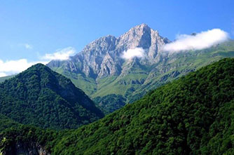
Armenia is a mountainous country:
It occupies about 29 thousand. 800 square kilometers (two: 360 km
from southeast to southeast, 200 km from east to west).
Located in southern Transcaucasia, where the Caucasus communicates
with Central Asia, the Iranian "plateau of Asia Minor" is almost 500m
above them. That is why it is called "mountain island".
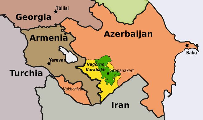
It borders Georgia (190 km) to the north, Azerbaijan (910 km
together with Nakhichevan) to the east, Turkey (280 km) to the west, the
Islamic Republic of Iran to the south (42 km) and the Republic of Nakhichevan .
The total length of the borders is 1,422 km.
In old maps, Armenia extends from the Caspian Sea to the
Mediterranean Sea. However, its main core is the Armenian plateau, which is
bordered on almost all sides by high mountain ranges. Pontus to the north, the
Little Caucasus to the northeast and the Armenian Bull to the south.
Modern Armenia occupies the northeastern part of the Armenian
highlands, with the Ararat valley in the center.
More than 90% of the surface is located more than 1000 m above sea
level.
The highest point is the gigantic biblical mountain Aragats, 4090
m high, the lowest is the Debed river gorge (380 m), the average height is
1,800 m.
The Armenian highlands are often referred to as the land of extinct volcanoes, but Nemrut volcano (west of Lake Van) was still geologically active yesterday, in 1441.
Geographical features

It is the most mountainous of the
Transcaucasian republics. Its mountains formed on the site of the ancient Tethys
Ocean, the bottom of which is still found in different parts of the continent.
The structure of the surface is very high,
the landscapes change with height, a new nature opens up behind each mountain
range.
Armenia is a land of contradictions, fertile
land and flourishing fields, but the kingdom of stones is vast.
Almost two thirds of the area is unusable for sowing.
The Highlands is a "geological
museum" where you can find samples of almost all the rocks that make up
the planet's crust, from the oldest to the youngest (Archaean or Pre-Cambrian,
Paleozoic, Mesozoic, modern, Cenozoic).
Relief parties are diverse. A region rich in
honey, molybdenum, polymetals and iron ores.
The variety and richness of useful excavations, such as gold, silver, precious building stones, which with unforgettable time, gained experienced Armenian masters, are distinguished. British archaeologist Gordon Child, among other researchers, found evidence that ancient Armenians were named after the first tribe in the world, who began to obtain useful excavations, equipped with iron and laid iron. The Armenian Highlands were the epicenter of the "Iron Age".
Climate
Armenia is located in a temperate zone, at the same latitude as the Balkans, the Apennines, the Iberian Peninsula, and receives as much radiation during the year as the countries on those peninsulas. However, its climate is different, due to the fact that it is far from the Atlantic Ocean. The climate of Armenia is also influenced by other factors, namely, being above sea level (vertical zoning), the surrounding mountains, the direction of the winds. Armenia is located in a temperate zone, ie at the same latitude as the Balkans, the Apennines, the Iberian Peninsula, and receives as much radiation during the year as the countries on those peninsulas. However, its climate is different, due to the fact that it is far from the Atlantic Ocean. The climate of Armenia is also influenced by other factors, namely, being above sea level (vertical zoning), the surrounding mountains, the direction of the winds. The climate of Armenia is characterized by high rainfall, with an average of 2,500 hours per year. Due to this feature, the Republic of Armenia is called Arvavar. The longest weather in the lowlands is summer (more than four months), and in the highlands - winter (about six months). The most pleasant season of the year is autumn, which is longer than spring everywhere!
Climate Features:
Ivan Chopin, a Russian statistician studying
the Caucasus, traveling to Armenia in the early 19th century, wrote: "In
Armenia, a traveler can reach from one point to the equatorial heat in one day,
ie almost a quarter of the Earth's circumference."
Indeed, sometimes you can see all four seasons at the same time. When apricots, peaches and grapes ripen in the Ararat Valley, from which the world's best brandy and delicious wines are made, and rise on the slopes of the surrounding mountains, the heat is not enough even for the grains to ripen, and at higher altitudes the snow does not melt all year round. Archaeological data and information provided by Armenian-Greek historians show that the climate of the Armenian highlands has changed very little during the historical period. The wine jars, grapes, apricots and peaches found during the excavations of the Urartian Teishebain fortress on the Red Hill prove that the hot and dry summers were also typical for the climate of the Ararat Valley in the distant past. This is evidenced by the remains of ancient irrigation canal. The climate of the middle mountain-steppe zone was "temperate" in the past, where in ancient times, as now, cultivated cereals. This is evidenced by the discovery of wheat grains in the tombs of Lchashen (near Lake Sevan). According to the sources, in the most distant historical times, the winters in the lowlands, as now, were quite cold, and in the high mountains - severe. The Greek historian Xenophon (IV century BC) in his "Anabasis" tells about the retreat of the Greek army through the mountains of Armenia, writes that at night, when the soldiers were asleep, snow fell, covered the people and their weapons, reaching overnight one meter thick. In the same work, he mentions that Armenians protected themselves from the cold by anointing their bodies with fat or bitter oil. One can get an idea of the diversity of the climate of ancient Armenia by reading Plutarch. Thus, he considers that the reason for the retreat of the Roman general Lucullus (1st century BC) was that his troops found plenty of food in the lowlands of Armenia during the hot summer months, while climbing the mountains where the grain was not yet ripe, they were forced to starve. They left the country.